Quick summary: Polygon mapping is revolutionizing supply chain management, allowing businesses to trace and verify sourcing practices, ensuring ethical compliance. Despite challenges, the environmental and societal benefits are significant. With advancing technology, polygon mapping is poised to become a standard in supply chain practices, paving the way for a genuinely sustainable and deforestation-free future.

Businesses are increasingly turning their attention to the concept of deforestation-free supply chains. As consumers become more conscientious about the products they purchase, companies are recognizing the imperative of aligning their operations with sustainable and ethical standards. This growing awareness has given rise to innovative technologies and approaches, such as polygon mapping, which play a pivotal role in ensuring that supply chains remain untainted by deforestation.
Leveraging GPS polygon mapping, which outlines the complete farm perimeter, adds an extra layer of visibility and vigilance, enhancing transparency and traceability within the agricultural supply chain.
In this blog, we will delve into the intricacies of polygon mapping, explore the profound importance of deforestation-free supply chains, and discuss its future trends and developments. By the time we conclude, you will have a deep understanding of how polygon mapping serves as a beacon for ethical and sustainable supply chain management.
The essence of polygon mapping lies in its capacity to provide a detailed and data-rich understanding of geographical areas, particularly those that are pertinent to supply chain operations. Before delving into the importance and intricacies of deforestation-free supply chains, it’s essential to comprehend the foundations of polygon mapping.
Polygon mapping, at its core, is a geospatial technology harnessed for the creation of precise and detailed maps of specific geographic areas. These areas are delineated using GPS coordinates, giving birth to a digital representation of land boundaries known as polygons. These polygons, visual representations of land areas, serve as an invaluable tool for various purposes, including supply chain management.
The process of polygon mapping unfolds through several key stages. It begins with the collection of data, particularly satellite imagery, which provides critical insights into the state of the land in question. The next step involves the analysis of these images, merging them with GPS coordinates to create accurate polygon boundaries. This mapping, which is often facilitated through geographic information systems (GIS), offers a visual overview of the land, making it more accessible for monitoring and management.
Polygon mapping draws its strength from the convergence of various data sources and components. Some of the pivotal elements that underpin this technology include:
With an understanding of what polygon mapping entails, let’s now venture into its pivotal role in maintaining deforestation-free supply chains.
Deforestation poses a significant environmental and ethical challenge, particularly for industries like agriculture and timber production. By adopting polygon mapping, businesses can meticulously map the land parcels they utilize in their production processes. This not only helps to ensure that their raw materials are sourced from deforestation-free areas but also facilitates the attainment of sustainability goals and compliance with ethical sourcing standards.
One of the standout advantages of polygon mapping is the transparency it affords. It empowers businesses and consumers with easy access to precise and up-to-date information regarding the origins of products. This transparency fosters trust and enables independent verification of sourcing practices. It’s especially invaluable for companies aiming to exhibit their unwavering commitment to ethical and sustainable sourcing.
Numerous countries and regions have enacted regulations aimed at curtailing deforestation and endorsing responsible land utilization. Polygon mapping provides companies with the means to ensure compliance with these regulations. It offers concrete evidence of their dedication to deforestation-free practices and enhances the capacity to oversee and report on land use changes and deforestation activities, thereby swiftly identifying and addressing any illicit practices.
In adherence to the updated EUDR regulations, businesses are mandated to achieve traceability down to the farm level, encompassing geolocation data. Geolocation data entails the location of an object determined by latitude and longitude coordinates. For farms smaller than four hectares, companies are required to furnish GPS data, while for larger farms exceeding four hectares, polygon mapping is necessary. Polygon mapping involves delineating the entire perimeter of a farm, contrasting with the provision of a single GPS coordinate.
Ensuring traceability to the specific plot of land, as mandated by the EUDR requirement to collect geographic coordinates, is crucial to demonstrate the absence of deforestation in a particular location. Various methods, including remotely sensed information like satellite images or field photographs with geotags and time stamps, can be employed for verification. The geolocation coordinates are integral to due diligence statements that operators must submit before placing products on the market or exporting them, as per the Regulation. Collecting these coordinates can be facilitated through mobile phones and freely available digital applications, such as Geographic Information Systems (GIS). The precision requirements for geolocation vary based on plot size, with polygons or single points specified for different scenarios.
The journey to responsible supply chain management is not without its share of benefits and challenges.
Foremost among the benefits is the remarkable contribution of polygon mapping to environmental conservation. By meticulously tracking and monitoring land use, businesses can make informed decisions that protect vital ecosystems and curtail the impact of their operations on forests. This, in turn, results in the preservation of biodiversity and plays a pivotal role in the global effort to combat climate change.
Deforestation frequently has a ripple effect, impacting not only the environment but also communities and their ethical rights. It can lead to the displacement of indigenous communities and the infringement of their rights. Polygon mapping empowers companies to respect the rights of local communities, ensuring that their sourcing practices do not encroach upon indigenous lands. This approach fosters social responsibility and upholds ethical conduct in supply chain management.
Now that we’ve explored the benefits and challenges of polygon mapping, let’s delve into the nitty-gritty of how businesses can effectively implement this technology in their supply chains.
The journey to adopting polygon mapping commences with a steadfast commitment to responsible sourcing and sustainability. Companies need to invest in the requisite technology, which includes GIS software and access to high-resolution satellite imagery. Collaboration with experts in geospatial technology can also prove instrumental in ensuring accurate mapping.
The integration of polygon mapping into supply chain management involves a series of well-defined steps:
TraceX’s geo-mapping feature not only facilitates the collection of geolocation data for EUDR compliance but also ensures accuracy in reporting, contributing to a seamless and transparent adherence to regulatory standards.
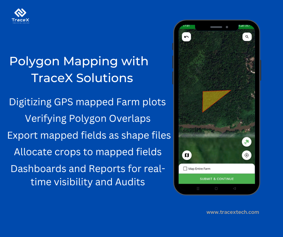
Precise Plot Mapping: TraceX enables companies to digitize and map the exact plot data of each farmer onboarded. This involves capturing the GPS coordinates of individual plots with unprecedented accuracy. Whether a farmer manages a smallholding or a larger agricultural area, the system ensures precise mapping of the land.
Efficient Data Collection: The solution employs user-friendly mobile applications, making it easy for farmers to contribute their plot data. The app facilitates offline data collection, allowing farmers to input information even in areas with limited connectivity. This streamlined data collection process ensures that the plot data is efficiently gathered from every farmer in the supply chain.
Polygon Mapping for Larger Farms: For farmers with larger agricultural areas exceeding four hectares, TraceX utilizes polygon mapping. This involves tracing the entire perimeter of the farm, providing a comprehensive view of the cultivated land. The system performs quality checks on the mapped polygons, ensuring accuracy and adherence to EUDR standards.
Integrated Reporting: The plot data, once mapped and verified, becomes an integral part of the reporting system. Companies can generate detailed reports that include the origin and geolocation of commodities from each farmer’s plot. This integration of plot data enhances the overall transparency of the supply chain and contributes to robust reporting mechanisms.
By incorporating farmers’ plot data into the geo-mapping feature, TraceX ensures that the entire supply chain, from individual plots to larger farms, is accurately represented. This not only meets EUDR compliance but also fosters a more comprehensive and trustworthy approach to supply chain traceability.
Polygon mapping emerges as a lighthouse guiding businesses toward ethical and sustainable supply chain management. It enables companies to trace and verify their sourcing practices, ensuring compliance with ethical standards and regulations. Although challenges exist, the advantages for the environment and society are substantial. As technology continues to advance, we can anticipate polygon mapping becoming a standard practice in supply chain management. This, in turn, will contribute to a more sustainable and responsible future, where the notion of deforestation-free supply chains is not an aspiration but a reality.
